Spatiotemporal variability of streamflow in the Pearl River Basin: Controls of land surface processes and atmospheric impacts
Research Background
The water cycle is crucial in linking the atmosphere-land-ocean continuum, promoting sustainable environment, and ensuring water security. Investigation of large watersheds in monsoon-affected regions is of importance, as they exemplify the characteristics of the monsoon areas that span 25% of the Earth's surface. The spatiotemporal variability of hydrological processes and the underlying mechanisms that regulate the terrestrial water cycle can be complex and not well understood. This lack of understanding hinders effective water resource management and the maintenance of societal well-being.
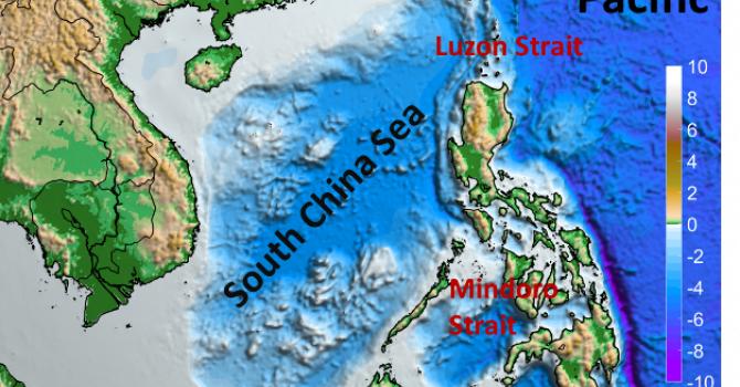
The Pearl River has an average discharge of 9631 m³/s and is the second-largest river in China in terms of annual streamflow. This water system consists of three main rivers: the West, North, and East River, and they merge into the Pearl River Delta and flow into the Pearl River Estuary. The Pearl River covers an area of 4.4×10⁵ km² in southern China and has a typical subtropical monsoon climate (Figure 1). The basin receives annual precipitation ranging from 1200 to 2200 mm/yr, with the wet season (April to September) accounting for nearly 80% of the total precipitation. The annual temperature varies between 14 and 22°C. The Pearl River Basin (PRB) has distinct geographic features, including the Yungui Plateau in the northwestern region of the basin, mountains in the northern parts, and plains in the coastal regions. It is home to 124 million people and provides essential societal, ecological, and economic services to the Guangdong-Hong Kong-Macao Greater Bay Area. Studying the streamflow characteristics and underlying controlling mechanisms in the basin is critical for understanding the frequent extreme floods and droughts in the region and the freshwater discharge into the adjacent coastal ocean.
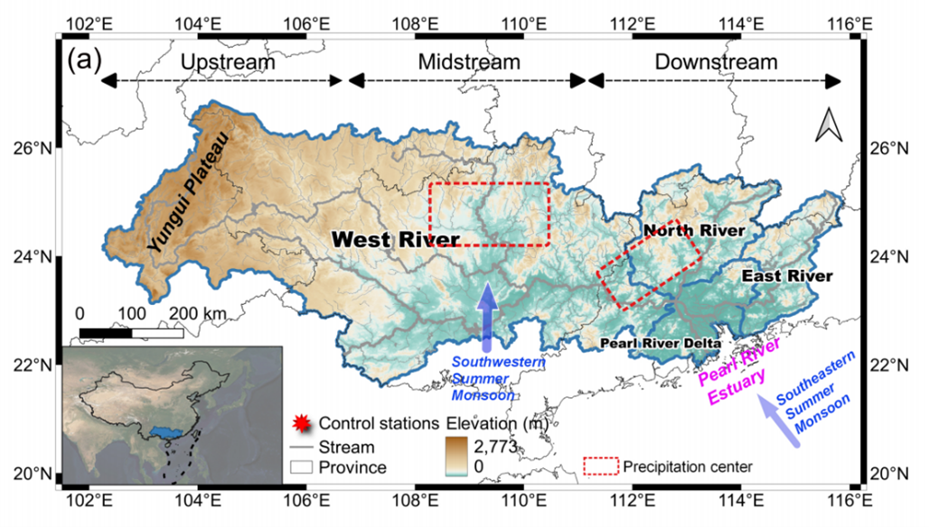
Figure 1. Location and topography of the Pearl River Basin.
Our study aims to achieve the following objectives:
1. Investigate the spatiotemporal characteristics of key water fluxes that control the streamflow in the basin.
2. Evaluate the interactive impacts of atmosphere-land surface properties on the water cycle in the PRB.
Results
We utilized the hydrological models, the Soil and Water Assessment Tool (SWAT+ version) to simulate and study the hydrological processes in the PRB. Figure 2 illustrates the significant spatial variability of each water flux in the PRB. Surface flow is active in areas with high precipitation, particularly in the midstream region, where values reach up to 500 mm/yr and extend towards the delta downstream (Figure 2a). In contrast, surface flow is less than 100 mm/yr in the inland upstream subregion. Lateral flow is active in the northern part of the PRB, with values exceeding 600 mm/yr, but it is relatively inactive in the coastal downstream, where it remains below 100 mm/yr (Figure 2b). The active zone of the aquifer flow is in the mid-south part of the midstream subregion (Figure 2c). Actual evapotranspiration (AET) is most active in the southern areas of the midstream region, suggesting a joint influence of solar radiation and regional land use (Figure 2e). In summary (Figure 2i), the upstream, located in the Yungui Plateau, has low streamflow and is a relatively hydrologically dry subregion. The midstream subregion is hydrologically active, where high values of multiple water fluxes intersect, including precipitation, AET, surface, lateral flow, and aquifer flow. The downstream subregion is close to the coastal margins and consists of the lower reaches of the West, North, and East Rivers.

Figure 2: Spatial distributions of key water fluxes: (a) surface flow (Qsur), (b) lateral flow (Qlat), (c) aquifer flow (Qaqu), (d) precipitation (Precip), (e) actual evapotranspiration (AET), (f) total flow (Qtot), (g) percolation (Perc), (h) recharge to shallow aquifer (Rchrg), and (i) summary of active zones. Coloured polygons correspond to the active zones of water fluxes in subplots (a) to (h).
Mechanism analysis
The land surface processes and regional land-atmosphere interaction control the spatiotemporal variability of the streamflow in the PRB. The spatial maps of topography, land use, soil, and precipitation presented in Figure 3 are linked to the active zones of the water fluxes in Figure 2. The local distribution of precipitation is influenced by the terrain topography, leading to a general decrease in precipitation with increasing distance from the coastal area (Figures 3a and 3d). The plains and hills allow water vapor to travel from the bay and coastal waters inland, creating an active precipitation zone in the PRB. In contrast, the high elevation (>1600 m) of the Yungui Plateau in the upstream region acts as a barrier, blocking the movement of warm and moist air to the headwaters of the West River, resulting in lower precipitation in this region. The precipitation pattern links to the active zones of other water fluxes (Figure 2) and plays a fundamental role in shaping the hydrological processes in the PRB.
Land surface properties, such as land use and soil properties, impact the redistribution among different water components. Agricultural land, for instance, experiences higher AET due to increased transpiration for crop growth (Figures 2e and 3b). Forested regions, on the other hand, have active lateral flow due to their high percolation rates (Figures 2b and 3b). Areas with extensive impervious surfaces, such as the Pearl River Delta, tend to convert most of the precipitation into surface flow (Figures 2a and 3b). Soil properties, particularly soil texture, further influence water infiltration and soil water dynamics, leading to deviations in the spatial distribution of surface and subsurface flow from the precipitation map. Notably, regions with high rock content exhibit active aquifer flow due to high percolation rates associated with coarse textures (Figures 2c and 3c).
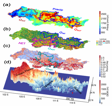
Figure 3. Spatial distributions of: (a) precipitation, (b) land use, (c) ratio of rock to clay (soil), and (d) topography. Coloured polygons in (a) to (c) indicate the active zones corresponding to Figure 2. AGRL, FRST, PAST, URBAN, and WATR represent agriculture, forest, pasture, urban, and water, respectively. The SCS represents the South China Sea.
Key points of the study
The hydrological processes in the PRB exhibit significant temporal (seasonal) and spatial (zonal) variability, highlighting the influences of monsoon climate and landscape features. Based on the analysis, we draw the following conclusions:
1. The fundamental patterns of hydrological processes in the PRB are shaped by precipitation, which is influenced by the monsoon climate and terrain topography. Land use and soil texture are significant to water redistribution in the soil profile and regulate the locations of the active zones of water fluxes. The surface flow is the most active within the precipitation centers. The lateral flow and AET dominate in the forests and agricultural regions, respectively, while the aquifer flow is more active in areas with coarse soil textures.
2. Based on the hydrological variability, the PRB can be divided into three substreams: a drought-prone upstream, a hydrologically active midstream, and a typhoon-affected downstream from west to east. Streamflow within each substream is interconnected and exhibits similar temporal patterns and statistical distributions.
For more detailed spatiotemporal feature analysis, please refer to Ying Zhang, Jianping Gan*, and Qichun Yang (2024), Spatiotemporal variability of streamflow in the Pearl River Basin: controls of land surface processes and atmospheric impacts, Hydrological Processes, https://doi.org/10.1002/hyp.15151.